1 hour ago
15
Published November 3, 2026 12:46 PM CST
MN weather: Rounds of rain continue Tuesday
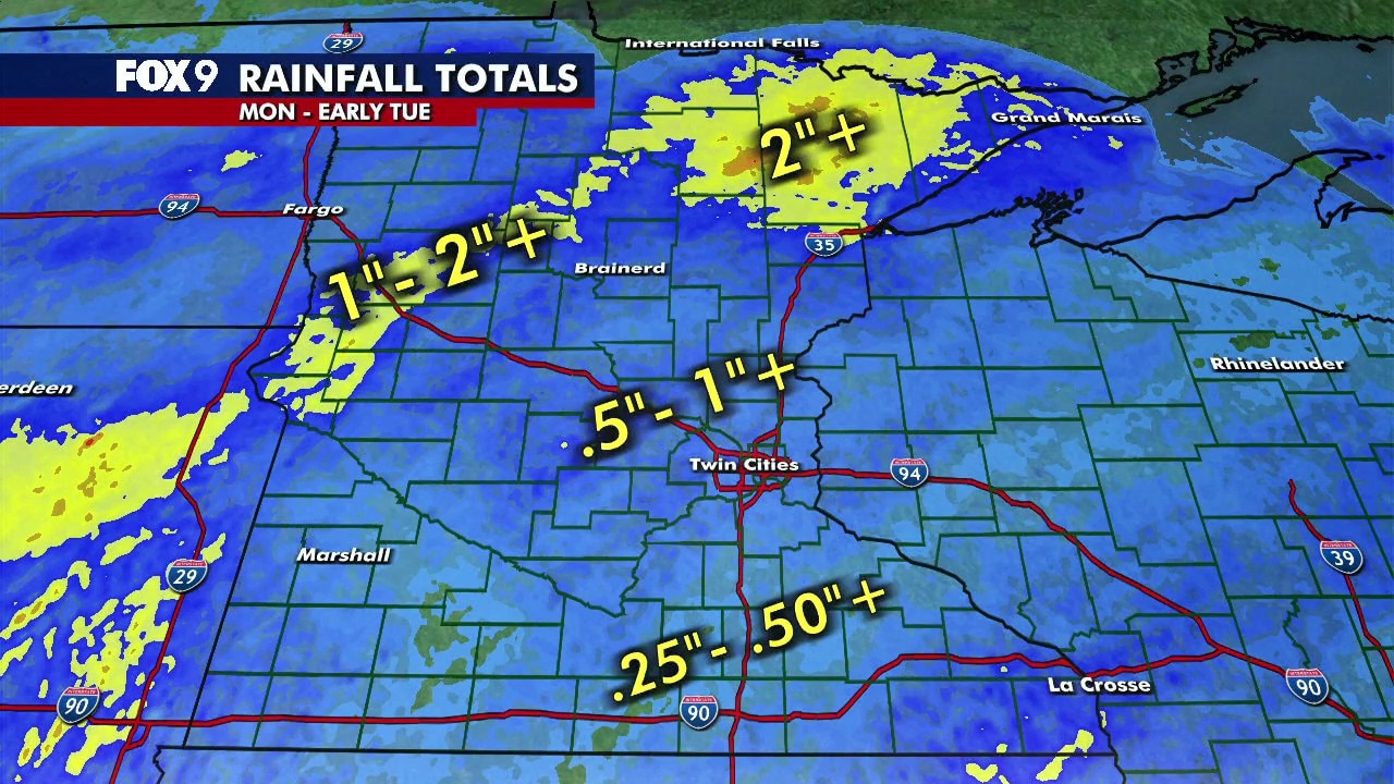
More rounds of light to moderate rain are expected across Minnesota Tuesday, with temperatures holding in the upper 50s. Steadier soaking rain arrives Tuesday night and continues through much of Wednesday, with an additional half inch to 1.5 inches of rain possible. FOX 9 Meteorologist Cody Matz has the forecast.
(FOX 9) - Widespread rain moved across Minnesota Monday into Tuesday morning, bringing more than 2 inches to parts of northern Minnesota, with additional rain expected through Wednesday.
Rainy start to November
The backstory:
The bulk of the rain moved through Monday, with some of the highest totals reported in northern parts of the state.
Rain showers will continue off and on through Tuesday afternoon and evening, with additional showers expected Wednesday. Another half inch to an inch of rain is possible over the next 40 hours.
Here's a look at the rainfall totals so far.
Statewide rainfall totals
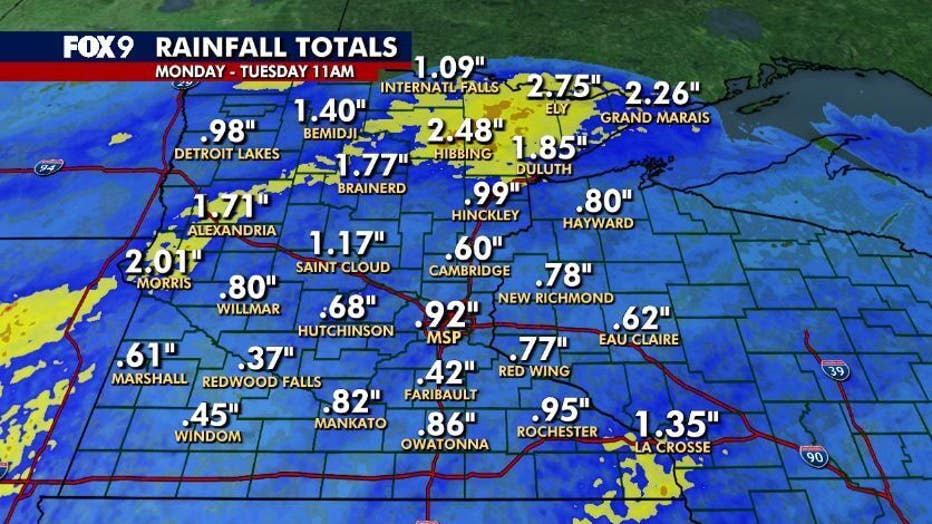
Statewide rainfall totals from Monday through 11 a.m. Tuesday. (FOX 9)
By the numbers:
Here's a look at statewide rainfall totals through 11 a.m. Tuesday:
- Ely: 2.75 inches
- Hibbing: 2.48 inches
- Grand Marais: 2.26 inches
- Morris: 2.01 inches
- Duluth: 1.85 inches
- Brainerd: 1.77 inches
- Alexandria: 1.71 inches
- Bemidji: 1.40 inches
- La Crosse: 1.35 inches
- St. Cloud: 1.17 inches
- International Falls: 1.09 inches
- Hinckley: 0.99 inches
- Detroit Lakes: 0.98 inches
- Rochester: 0.95 inches
- MSP Airport: 0.92 inches
- Owatonna: 0.86 inches
- Mankato: 0.82 inches
- Willmar: 0.80 inches
- Hayward: 0.80 inches
- New Richmond: 0.78 inches
- Red Wing: 0.77 inches
- Hutchinson: 0.68 inches
- Eau Claire: 0.62 inches
- Marshall: 0.61 inches
- Cambridge: 0.60 inches
- Windom: 0.45 inches
- Faribault: 0.42 inches
- Redwood Falls: 0.37 inches
Twin Cities metro rainfall totals
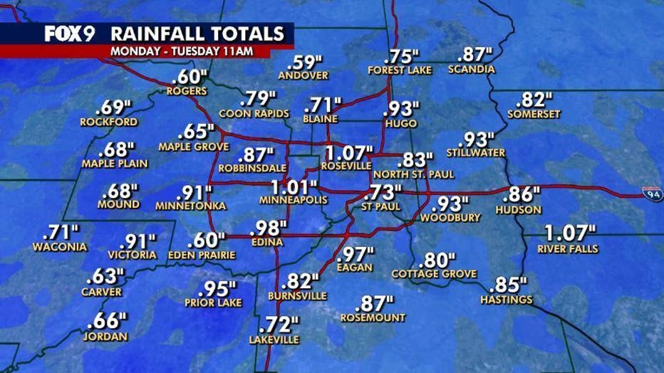
Twin Cities metro rainfall totals from Monday through 11 a.m. Tuesday. (FOX 9)
By the numbers:
Here's a look at rainfall totals across the Twin Cities metro as of 11 a.m. Tuesday.
- River Falls: 1.07 inches
- Roseville: 1.07 inches
- Minneapolis: 1.01 inches
- Edina: 0.98 inches
- Eagan: 0.97 inches
- Prior Lake: 0.95 inches
- Hugo: 0.93 inches
- Stillwater: 0.93 inches
- Woodbury: 0.93 inches
- Minnetonka: 0.91 inches
- Victoria: 0.91 inches
- Robbinsdale: 0.87 inches
- Scandia: 0.87 inches
- Rosemount: 0.87 inches
- Hudson: 0.86 inches
- Hastings: 0.85 inches
- North St. Paul: 0.83 inches
- Somerset: 0.82 inches
- Burnsville: 0.82 inches
- Cottage Grove: 0.80 inches
- Coon Rapids: 0.79 inches
- Forest Lake: 0.75 inches
- St. Paul: 0.73 inches
- Lakeville: 0.72 inches
- Waconia: 0.71 inches
- Blaine: 0.71 inches
- Rockford: 0.69 inches
- Maple Plain: 0.68 inches
- Mound: 0.68 inches
- Jordan: 0.66 inches
- Maple Grove: 0.65 inches
- Carver: 0.63 inches
- Rogers: 0.60 inches
- Eden Prairie: 0.60 inches
- Andover: 0.59 inches
Record-breaking rainfall in northern MN
Dig deeper:
Several northern Minnesota cities broke daily rainfall records Monday, Nov. 2, according to the National Weather Service in Duluth.
Hibbing recorded 2.18 inches of rain, shattering its previous daily record of 0.53 inches set in 1992. Duluth also set a new daily rainfall record with 1.48 inches, surpassing the previous record of 1.22 inches set in 1961. International Falls recorded 1.05 inches, breaking its previous record of 0.62 inches set in 2000.
In addition to the rainfall records, several cities set new records for their warmest daily low temperatures Monday. Duluth and International Falls both recorded lows of 52 degrees, while Brainerd reached 55 degrees.
The Source: This story uses information from FOX 9 meteorologists and the National Weather Service.
WeatherMinnesota